On Sunday, February 28th my friend Kevin Douglas and I set out to be the first people I know of, to complete a single day HSCT in the winter.
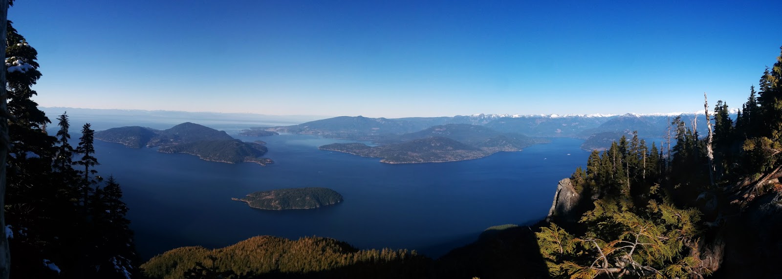
A bit of background. The Howe Sound Crest Trail is a 28km'ish / 17 mile'ish point to point run along the spine that connects the Cypress Ski Resort area to Porteau Cove. In the traditional Cypress to Porteau direction you face approximately 1850m / 6000ft of climbing and 2750m / 9000ft of descent. I hold the FKT (Fastest Known Time) at 3h45m which I ran in near perfect conditions on August 4th, 2014. The average fit ultra running party will take between six and ten hours to complete a summer crossing.
I first ran the HSCT in September of 2007 with this group of misfits.

Peter Watson lead the way as the only person to have completed it prior. We were all instructed to carry our ten essentials and debriefed on how challenging the route really was. On that day, in reasonable conditions (some clouds and moisture) I watched the closest thing I've yet to witness in person to one of my party needing to be extracted. Late in our run Peter slipped on a side slope and fell off of an eight foot drop. Somehow, he managed to do a half barrel roll in the air and to land upright while bracing himself against a tree. In the 100 ways that fall could have ended, about 70 of them involved a broken ankle/arm/face, 25 involved a strain serious enough to necessitate extraction, and five of them ended without a scrape. On that day we were fortunate to have landed in the 5%. Even during favorable conditions the HSCT is to be taken seriously. There are some 'outs' along the way, some alternate trails that can take you down to Lion's Bay to shorten the route, but they still involve a 4000ft vertical descent. If anything goes wrong out there, you'll be getting to know the NS Search and Rescue guys on a first name basis.
It was with all this in mind, oh and I also need to throw in that I had gone on to complete the HSCT five times since 2007, with this being my sixth go at it. It was with all the above in mind that I set out with but one goal, don't be 'that guy', the guy who's wife has to call NSSR and they respond with, "I'm sorry he's doing what today? Is your husband an idiot?"
North Shore News: "Local idiot extracted from HSCT in Feb. Lucky to be alive."
I've been eyeing the HSCT for all of February. As we all know this is the craziest form of 'winter' we've ever experienced here on the coast. I thought it would be really cool to complete the trail on the one year (hopefully in my lifetime) that it's possible to do so in the winter. Over the past few weeks I checked out St Mark's Summit and other higher points on Grouse (Crown) and Seymour (Peak) to get a true handle on the snowpack. I was confident in giving it a go and the forecast looked favorable, then we got a dousing of snow up high on Thursday night (26th) and I knew I had to reassess. I was well aware of the fact that although the trail may be passable today, that will all change with one snow system.
There was no way I was heading out there alone. There was no way I was heading out there in a group, and there was no way I was heading out there without someone I trusted and that I knew could not only handle the conditions but who could keep an open line of communication going throughout the day. I reached out to my buddy Kevin who lives in Bellingham. He's a HURT 100 finisher, recently won the Orcas Island 25k and regularly heads out in the mountains on his own, while always packing more safety supplies than any runner I know. A few weeks back he got to 6,000ft in the North Cascades, while carrying a full sleeping bag and all necessary kit in case he ended up needing to spend the night. In short, I chose my partner very wisely.
Our mandatory kit consisted of a full change of waterproof breathable clothes, extra gloves, first aid, fire kit, headlamps, knives, whistles, emergency bivy, compass, cell phones, microspikes and most importantly, ice axes. Microspikes were the bare minimum and if my mountaineering crampons fit onto my shoes I would have packed them without second thought.
We agreed that each of us had the power to call it a day at any point in time should we feel uncomfortable continuing. If we made it safely through to our first 'out point' at Lion's Bay we'd reassess our day there to see if it made sense to continue. We held zero illusions about the likelihood of success and I gave it 60% odds that we'd complete the full route, 30% that we'd turn back and 10% that we'd call it a day near Lion's Bay.
With the fresh snow up high and below freezing overnight temps I wanted to line up our day as best as possible with the freeze thaw cycle. I would normally start a HSCT attempt at first light, especially on a shortened winter day, but I knew getting up into the alpine too early would place us on precarious icy slopes. I wagered that 8:30am was as late as we could successfully start while giving us enough daylight to work with. We began our day at 8:30am on the dot.
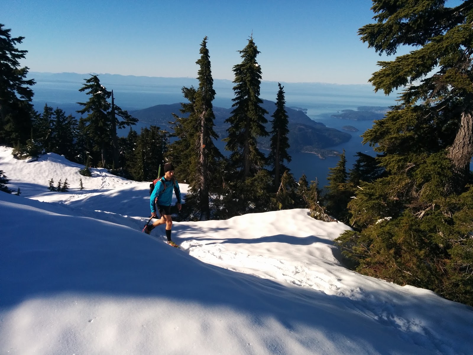
Saturday's conditions could not have been any better. Literally not a cloud in the sky with the daytime high getting up around 14. This was a determining factor in deciding to give it a go and if the day were even overcast we would have had a completely different experience out there.
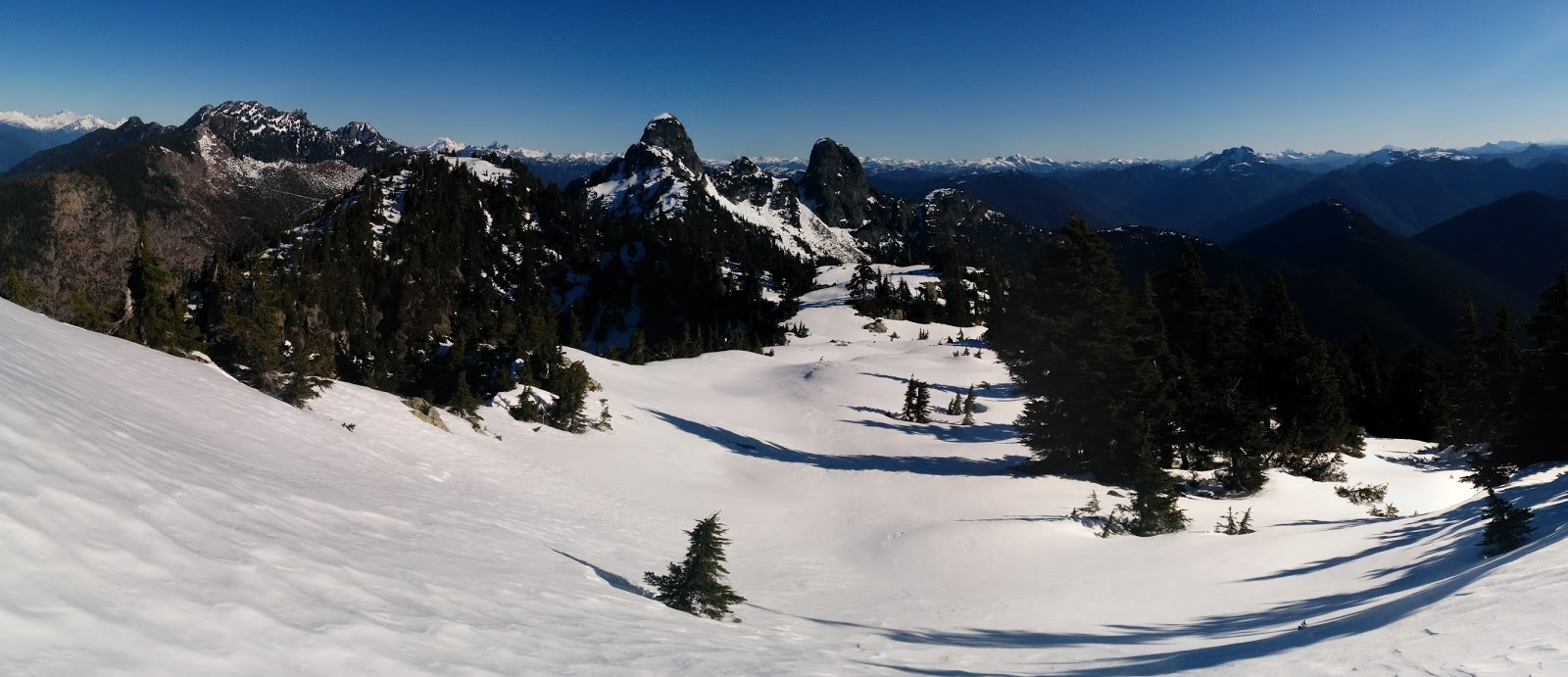
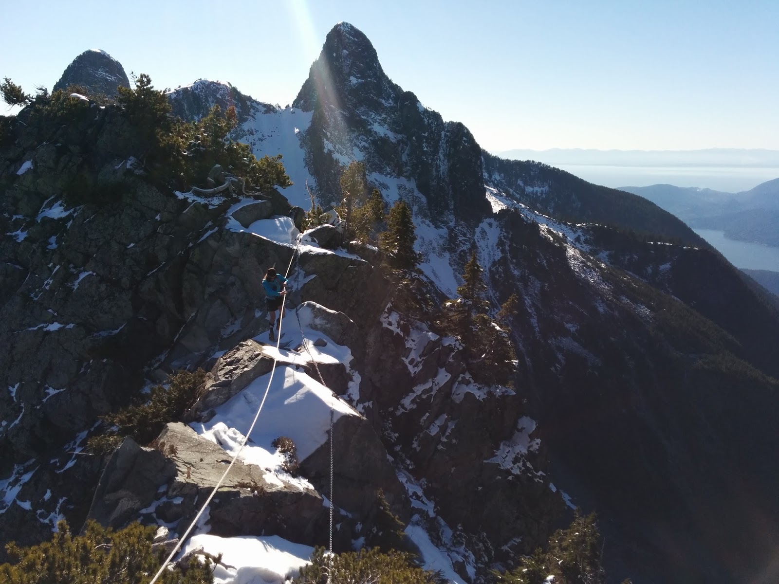
Even before we reached St. Mark's Summit I could see the evidence of the recent snowfall. It gave me pause for concern but we pushed on until Mount Unnecessary. There were plenty of tracks out as far as here but then none going further. With the trail under snow the navigating was challenging and I missed the turn to take us down away from the West Lion, instead descending the rope to put us in the saddle that would lead into the summit scramble. We took a few minutes to assess before continuing back up the rope to find the turn hidden just above. We started down the chute and up until this point things were proceeding without issue. At the bottom of this slope there is a traverse back towards the saddle of The Lions. This would become our first reasonable challenge. The sun was starting to warm the slope, thankfully, but a layer of ice was just below the softened snow and we spent about fifteen minutes using our axes to safely negotiate the crossing. One spot in particular was a 'no fall zone' in which we took extra care.
At this point we could spot evidence of footprints off in the distance. My best guess was that they were a week old as they were mostly buried, yet just discernible enough to realize what they were. For most of the rest of our day these prints would alternate between, completely buried, to "I think those are prints", to "those are definitely footprints", all based on our slope, the sun exposure and some snow drift.
Though slow going we made our way up into the saddle beyond The Lions without issue. It was noon and we had already been out three and a half hours. When I ran the trail in August I was already in the final miles after 3.5hrs. It was gonna be a long day out.
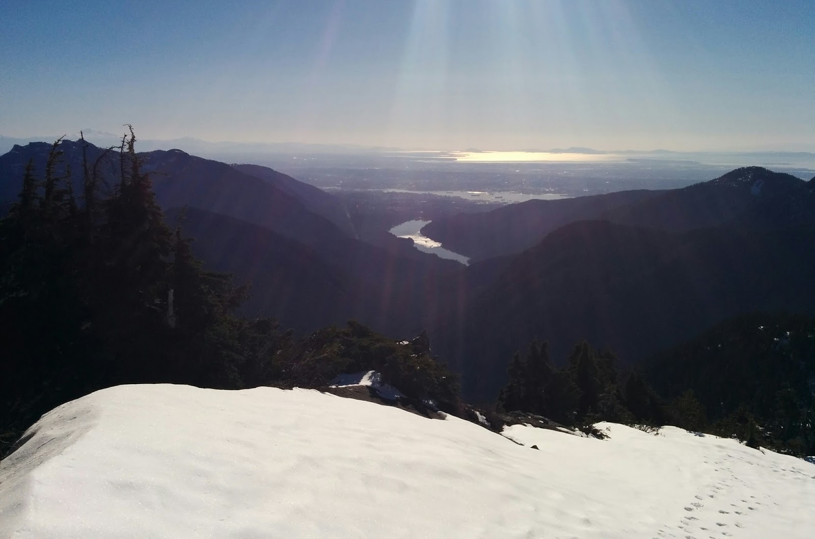
Dropping off this ridge was a bit of a thrill. It's a tight line coming down and you find yourself tip toeing between not stepping in the snow on the cliff edge to your left (a slide of a few thousand feet) and trying to use the fleeting foliage to your right for purchase. It was at this point that I was wishing I'd GoPro'd the day. It's completely impossible to capture this in pictures yet a head shot video clip would have summed it up nicely. I wasn't fearful for my life, but we were both aware that this was a 'no mistake zone.'
Maybe a mile later you drop down a slope that in the summer is a boulder field. All but the largest boulders were under snow and as I was working my way down I lost my footing and started to go for a ride. I self arrested without issue. This wasn't a life of death slide towards a cliff or anything, but it was certainly going to lead to a lengthy and unpredictable ride if I was unable to stop it. We had taken our axes off our packs around Unnecessary, and they would stay in hand all the way through to Hanover Lake.

My guess in advance of our day was the the crux of our route would be between The Lions and just above Enchantment Lake, but the snow was not dissipating and the route finding became increasingly challenging. Had I not already completed the trail five times the route finding would have been near impossible. I was silently patting myself on the back all day long as I correctly lead us towards the intermittent and at times nearly invisible trail markings. The problem of course being that minus the snow the singletrack trail is self explanatory and completely without need for constant markings. Just above Hanging Lake the trail splits and you can proceed around the final rock summit or up and over. (this might be called David's Peak?) I have never once gone around and hence I had no inkling of how to navigate the alternate route if we did chose it. We struggled for ten minutes just prior to here to find the trail at all, and once we did it appeared that the alternate choice, easier on paper, traversed an unstable side slope. I had to stick to what I knew, and that meant up and over.
The summer route over this summit involves some hand hold areas while ascending rocky slopes, but when under snow these become less desirable. I knew where we had to go and I set us on course up a steep pitch of snow in which our axes were all that kept us from ripping back down into the trees below. I was nearing the edge of my comfort zone and Kevin expressed his dissatisfaction with the situation. I had mistakenly told him that our previous summit was our final big challenge of the day and after that it would get progressively easier, instead we found ourselves in the most onerous part of our day.
We eventually topped out about thirty minutes later, and given that it was such a stunning day whenever we weren't moving we were really enjoying being out in the sun. The pictures we snapped throughout the day reflect the weather, not the dangers that we navigated to collect the imagery.
Me "Do you want the good news or the bad news?"
Kev "Good news."
"It sure is beautiful out here today!"
"Bad news...."
"I don't recognize anything from up here right now. I'm not 100% certain I've been here before, I don't see a safe way to get down off of this, and we may have to back track if we can't work this out."
There was a lower summit to our right, though from where we stood you couldn't tell if they connected. You can't assess a problem until you have all the information at hand, so we continued one step at a time, collecting more information as we went. Thankfully we found a route down, and to our great relief I found two pieces of flagging tape! The picture came together in my head. I had not previously stood up where we were, but I now recognized things again. I had taken us up the summit early, and higher than necessary but we now found ourselves back on track again, there was just one issue. In the summer there is a rock ledge with ropes in place to down climb, but that was all buried in snow. We were going to have to improvise. We found a gully and used our axes to maintain control while butt sliding a few steep slopes. We then searched for flagging for about five minutes before picking up the route again. There were a few more dicey bits before we were finally safely down. It had taken us a full hour. We have covered 800 meters of total distance, one half mile.
We had officially reached the Lion's Bay pull out area in 6h10m. Standing in the sunshine, having successfully tackled a stressful situation as a cohesive unit we took a moment to soak it all in. It truly was a magnificent day to be out in the mountains.
At this point I was certain our difficulties were behind us and that it'd be smooth sailing on out to the car, even though by distance we were pretty much only half way through.
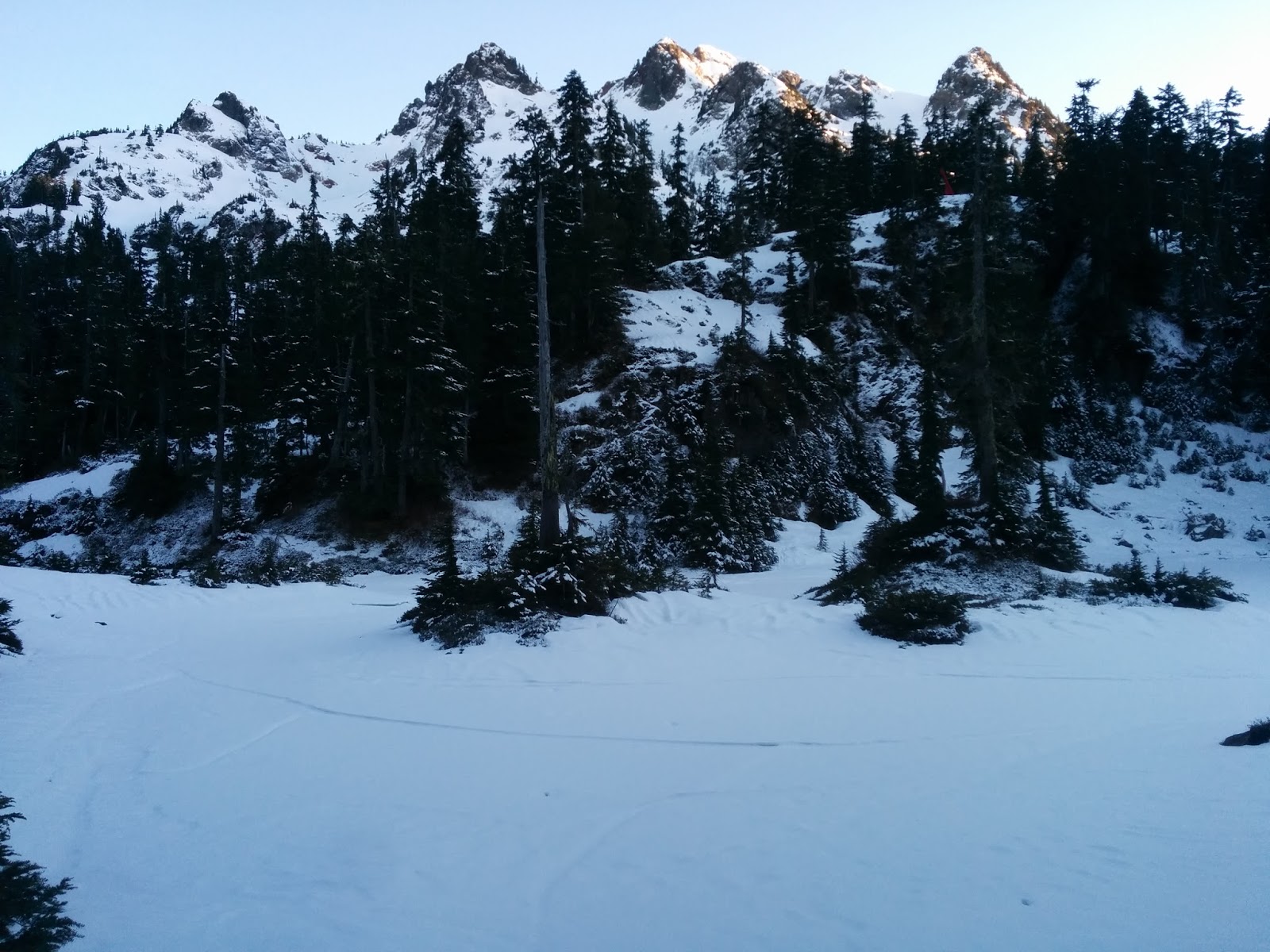
We made good time over to the safety shelter at Magnesia Meadows where we briefly stopped for lunch. We were both dreadfully shy on water for the day. It wasn't that I expected to find any on route, it was that to go fast and light makes this necessary. I envisioned our day taking under eight hours and figured I could squeeze by on 1.5 liters while using some snow if need be. It had taken us six and a half hours to MM and I was now dipping into my third and final 500ml flask.
Thirty minutes past MM and we lost the trail. Everything was still under snow but there were obviously many hikers who'd come up to the meadows and the buried footprints were consistent. I think we got caught following an errant set of prints and while they likely turned back to re-calibrate we were solidly in 'get this shit done mode' and we pressed on, up around and eventually back down an open snow gully via our now perfected axe controlled butt slide to gain the trail again. Thankfully I managed phone service and called Linda to let her know we were safe but still hours away from finishing.
When you combine the physical demands of the HSCT with the mental demands of attempting it in winter and you cap it off with a lack of calories and fluids, you can end up with an unbelievably stupid, embarrassingly dumb mental gaffe.
We came to a split in the trail. There were no tracks to the right and it was buried in snow. To the left was all but tracked out and mostly snow free. We had cleared our obstacles and our objective was at hand. I turned left, and we started thumping down our final 4500ft / 1400m descent to the car. It took ten full minutes of switchbacked downhill running before it slowly clicked over in my head.
This isn't right. Where's the cabin? Why have we lost so much elevation already? Why am I looking in the wrong drainage right now?
"F#@K!!!!!"
"What?"
"F#@K!"
"What?"
"F#@K!!"
"What!?"
"F#@k, f#@k, f#@k, turn around. I took a wrong turn. We have to climb back up again."
"It's okay Gary. No worries."
"I know Kev. I appreciate it, but I can't believe what I just did."
We were already way behind on our ETA for the day and I had just tacked on an extra thirty minutes and nearly 1000 extra feet of descent and climb.

Twenty minutes later we took the correct turn and proceeded to break trail. We were thrown right back into the navigation issues again and this was compounded by dwindling daylight. We knew we were going to be out after dark and that we had to make hay while we could, for attempting to route find in the snow by headlamp would have been too dangerous to entertain.
Feverishly working together we spread out and called a marker when we spotted one. I know the general lay of the land through this section but was dumbfounded by how this area in particular was disguised under snowfall.
We picked our way down, coming out just below the Brunswick Lake shelter. We lost the trail again shortly thereafter for a few before finally getting on route and running down past Hanover and Deeks Lakes to attempt to get below snowline before having to crack out our headlamps. We managed just that and at about 800m / 2500ft where we finally packed our axes away and popped on our lamps.
As soon as we clicked on our headlamps I had but one thought.
"I f#@king love this shit."
Forty thankfully uneventful minutes later and we closed it out.
10h12m
8000ft / 2500m climbing
11,000ft / 3350m descent
I couldn't have picked a better partner. We could not have had a better day. You could not convince me to do it again in the winter! That was a one off and I'll celebrate our good fortune that came from our communication, our patience, our decision making, our navigation through experience and the endurance we've accrued through years of training.
I DO NOT recommend attempting this and if you are 'inspired' to try this after reading this blog than you've either got years more experience than I do, or you've missed the point entirely.
Mountaineering boots, crampons, axes, an experienced party on a multi-day staying in a shelter overnight mission, sure, until it snows I think that's probably doable. How we travelled though? I'll say unless you're a confident mountaineer with at least four or five crossings of the trail and at least one of them being under four total hours, it's probably best to put it off till summer. That of course leaves Nick Elson and Eric Carter, both Skimo racing in Europe this winter. If you're name isn't Nick Elson or Eric Carter, I absolutely do not condone an attempt on a single day crossing under the current conditions.
Suunto Movescount
Twitter user peterdubya confirmed my suspicions on the intermittent week old foot prints
GR


7 comments:
Good stuff Gary and Kevin. It indeed is the winter for doing some crazy things that wouldn't otherwise be "doable."
-Luke
I remember the first time we ever did this so vividly. Perhaps it helped that there was no views to remember but I have done it every year since then and it's one of my favorite runs of all time.
Thanks for sharing :)
Even if you run all over the world the next adventure is waiting in your backyard.
Thank you very much Gary!
Unbelievable awesome performance!
You are starting to look like a guy I met on the PCT who's trail name was Beardo! Nice Work, mate. What a beautiful day!!
You are starting to look like a guy I met on the PCT who's trail name was Beardo! Nice Work, mate. What a beautiful day!!
Awesome post, a very entertaining read! has anyone done this trail in recent weeks? we are planning to give it a go this weekend but are unsure of the current trail conditions. I dont usually head out on this trail till late june, but im hoping the poor snowfall this season means it will be clear!
I hiked this trail last May and the snow was still deep. Reading your report was like reliving that day. The iceaxe buttslides left me sore for a week.
Post a Comment